Learn About Maps
Clicker Version 8
Learning Level: Primary School
About this Resource
This Clicker Grid Set is a unit of activities designed to support Early Learners who are learning about maps.
These activities support the BC Ministry of Education Prescribed Learning Outcomes for – Social Studies Grade 2
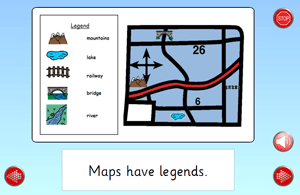
– interpret simple maps using cardinal directions, symbols, and simple legends.
Created by SET BC Region One Staff – North Island. grade 5
Under BC’s new curriculum (2016):
Social Studies 1, 2, 3: Use Social Studies inquiry processes and skills to: ask questions; gather, interpret, and analyze ideas; and communicate findings and decisions. Grade 1 key skills: Recognize that maps are used to represent real places; Relate pictorial representations to their physical locations (e.g., a place within the school, a neighbourhood park); Follow a path to a destination using a pictorial representation (e.g., picture map). Grade 2 and 3 key skills: Use cardinal directions to identify relative locations on simple maps (e.g., the school is north of the park)
Interpret symbols and legends on maps to identify given locations in the community (e.g., schools, roads, railways, playgrounds, museums)
Resource Files
Please Note: These files can only be downloaded on desktop. Visit the SET-BC website on a desktop computer to access them.
-
Learn About Maps (7 MB)